


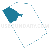
Voting District 0204, Limestone County, Texas
About
Outline

Summary
| Unique Area Identifier | 675486 |
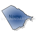
| Name | Voting District 0204 |
| County | Limestone County |
| State | Texas |
| Area (square miles) | 129.69 |
| Land Area (square miles) | 128.47 |
| Water Area (square miles) | 1.22 |
| % of Land Area | 99.06 |
| % of Water Area | 0.94 |
| Latitude of the Internal Point | 31.65750000 |
| Longtitude of the Internal Point | -96.79477700 |
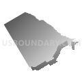
Maps


Graphs
Select a template below for downloading or customizing gragh for Voting District 0204, Limestone County, Texas


Neighbors
Neighoring Voting District (by Name) Neighboring Voting District on the Map
- Voting District 0023, Hill County, TX
- Voting District 0069, McLennan County, TX
- Voting District 0070, McLennan County, TX
- Voting District 0071, McLennan County, TX
- Voting District 0092, McLennan County, TX
- Voting District 0203, Limestone County, TX
- Voting District 0205, Limestone County, TX
- Voting District 0301, Limestone County, TX
- Voting District 0303, Limestone County, TX
Top 10 Neighboring County Subdivision (by Population) Neighboring County Subdivision on the Map
- Groesbeck CCD, Limestone County, TX (5,915)
- Mart CCD, McLennan County, TX (5,788)
- Axtell CCD, McLennan County, TX (4,012)
- Hubbard-Mount Calm CCD, Hill County, TX (2,579)
- Coolidge CCD, Limestone County, TX (1,302)
- Prairie Hill CCD, Limestone County, TX (878)
Top 10 Neighboring Unified School District (by Population) Neighboring Unified School District on the Map
- Mexia Independent School District, TX (11,516)
- Groesbeck Independent School District, TX (9,644)
- Mart Independent School District, TX (3,467)
- Axtell Independent School District, TX (3,134)
- Coolidge Independent School District, TX (1,422)
- Mount Calm Independent School District, TX (769)
Top 10 Neighboring State Legislative District Lower Chamber (by Population) Neighboring State Legislative District Lower Chamber on the Map
- State House District 10, TX (184,699)
- State House District 56, TX (155,303)
- State House District 8, TX (149,393)
- State House District 57, TX (144,556)
Top 10 Neighboring State Legislative District Upper Chamber (by Population) Neighboring State Legislative District Upper Chamber on the Map
Top 10 Neighboring 111th Congressional District (by Population) Neighboring 111th Congressional District on the Map
Top 10 Neighboring Census Tract (by Population) Neighboring Census Tract on the Map
- Census Tract 9706, Limestone County, TX (5,915)
- Census Tract 35, McLennan County, TX (4,012)
- Census Tract 9614, Hill County, TX (3,915)
- Census Tract 36.01, McLennan County, TX (3,174)
- Census Tract 9701, Limestone County, TX (2,180)
Top 10 Neighboring 5-Digit ZIP Code Tabulation Area (by Population) Neighboring 5-Digit ZIP Code Tabulation Area on the Map
- 76667, TX (11,313)
- 76642, TX (7,057)
- 76664, TX (3,514)
- 76648, TX (2,302)
- 76624, TX (2,231)
- 76635, TX (1,341)
- 76673, TX (1,187)
- 76678, TX (263)